Retracing Their Steps
To get a sense for the scope of the Hayden Expedition, I compared a current park map [1] (shown below) with place names and maps from the original journals of survey members. As I traveled through the park, I identified features described in 1871, trying to imagine the scene through their eyes.
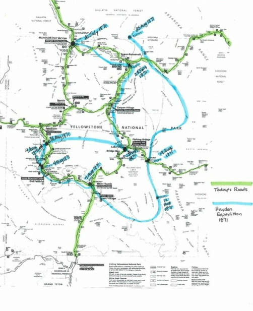
"From Bottler's Ranch we proceeded up the valley of the Yellowstone, surveyed the remarkable hot springs on Gardiner's River, the Grand Canon, Tower Falls, Upper and Lower Falls of the Yellowstone, thence into the basin proper, prepared charts of all the Hot Spring groups, which were very numerous, and continued up the river to the lake. We then commenced a systematic survey of the lake and its surroundings. Mr. Schonborn, with his assistant, made a careful survey of the lake and the mountains from the shore, and Messrs. Elliott and Carrington surveyed and sketched its shore-lines from the water in a boat. Careful soundings were also made, and the greatest depth was found to be three hundred feet. From the lake I proceeded, with Messrs. Schonborn, Peale, and Elliott to the Fire-Hole Valley, by way of East Fork of the Madison; then ascended the Fire-Hole Valley. We made careful charts of the Lower and Upper Geyser Basin, locating all the principal springs, and determining their temperatures. We then returned over the mountains by way of the headwaters of the East Fork by way of the valley of Pelican Creek, explored the East Fork to its junction with the main Yellowstone, and thence to Bottler's Ranch, which we reached on the 28th of August." --Ferdinand Hayden [2]
- "Yellowstone," map, in Yellowstone National Park: Its Exploration and Establishment (National Park Service,U.S. Department of the Interior, 2012).
- F. V. Hayden, Preliminary Report of The United States Geological Survey of Montana and Portions of Adjacent Territories; Being A Fifth Annual Report of Progress (Washington: Government Printing Office, 1872), pg. #xiv.